|
|
|
|
|
|
|
Title, deconstructed ...
MTB: mountain bike Because, Leadville. (August 15.) kanc: The Kancamagus Scenic Byway loop in the White Mountains I rode my first Kanc loop in September of 2010 (I've since ridden the loop or in the general area on the order of a dozen times). What I think of as THE Kanc loop is counter-clockwise version. I've started it in Franconia (map below), in Lincoln, and now in Bartlett.  PLUS: Jericho Road and bike path add-on The Kanc loop "proper" is on the order of 92 miles. Leadville is 104. So I wanted to add some miles. Starting at the Schussverein on Jericho Road added about 5 1/2 miles. Adding the Franconia Notch Bike Path tagged on another 12. Michelle M and I ended up with 111 miles on the Garmin. 6 Notch: notch = mountain pass The standard Kanc loop is five notches. (In VT, they call them gaps. Out in the Rockies, they call them passes. In Frenchy-type places, they call them cols.) In the "traditional" order from a Lincoln start, that's Kancamagus, Bear, Crawford, Franconia, and Kinsman. By virtue of going down and up the bike path from Franconia, we earned a second Franconia. CRW: Crawford Notch The short Crawford Notch climb itself, from Silver Cascade to Flume Cascade, is probably the steepest pitch of the loop. I saw a steady 15% on my Garmin. My imagination of Crawford is always more fearsome than the actual climb itself. The real challenge of Crawford is the lead-up. From the intersection of Route 302 and Bear Notch Road, it's a 13 mile climb averaging a 1% to 2% grade, Then, the pitch turns up enough to sap your strength before you get to the wall. Oh, and there's always a headwind. 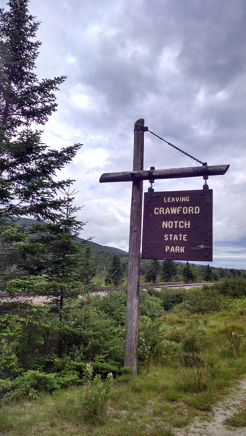 FRA: Franconia Notch Franconia Notch is the least notchy of the notches. Its "peak" is about the same elevation as Crawford Notch. From Crawford, you descend for a bit, level out for a bit, and climb for a bit, but for the most part, none of the grades are particularly steep. The challenge of this stretch isn't the grade, it's the aforementioned headwind and the sometimes lack of attractive scenery. This particular transit of the post-Crawford leg on 302 introduced one novelty, though. Up ahead, we heard what sounded to our lay ears like a gunshot. Up ahead, on the other side of the road, we saw a parked SUV. And a man with a long gun of some sort. Perhaps against our better judgement, we continued on, eventually making out that the SUV was a police vehicle and that the man was a shotgun-brandishing officer of the law. No idea what he shot. But #blacklivesmatter, we're just saying. FRA: Franconia Notch Franconia Notch from the south is at least a little more notchy. By throwing in the bike path down to the Flume parking lot and back, we not only added miles, we added a great change of pace from generally busy roads. And, the Flume visitor center made for a great refueling center--the stop there was the vast majority of our 1h 25m non-moving time. More on non-moving time later. 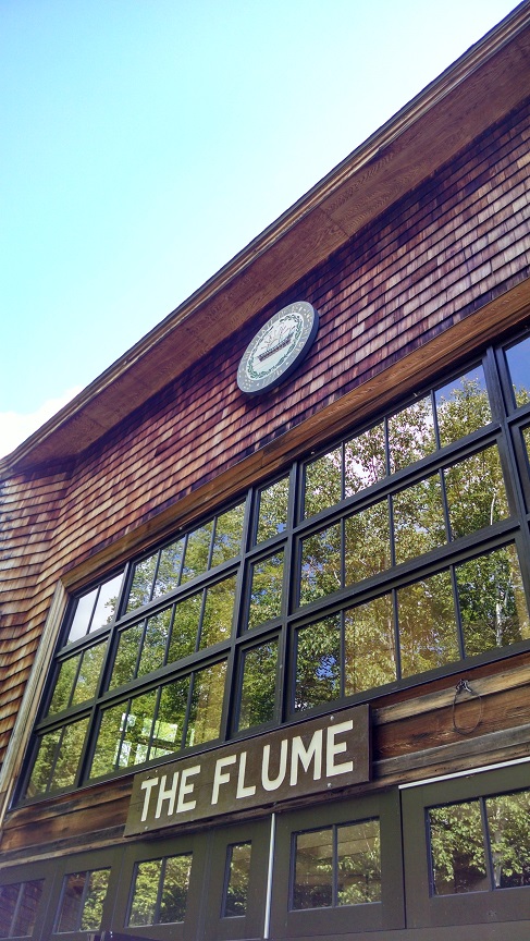 KIN: Kinsman Notch Back at the top of Franconia Notch and the bike path, we talked through the descent down Profile Road/Route 18. It's a steep descent on sketchy pavement, and part of the way down, there's a left on Kerr that can be easy to miss. We navigated the turn with no problem, but stopped immediately to debate our rain avoidance strategy. Because it was raining. Hard. Just as we had started the descent, we heard a loud thunderclap. Well, now it was delivering. Our options included continuing or heading into Franconia itself to take shelter in one of the stores. We chose "continue," endured the chill of the rest of the descent, and turned left at the airfield onto Route 116. Where we encountered dry roads. Correct decision. Route 116 begat the left onto 112 and the false flat before the real climb started. The Kinsman Notch climb isn't all that long, but it occasionally gets steepish. We crested the top and started the long, straight descent into Lincoln. Along the way, I notched my fastest speed ever on a bike, 52.6 mph, topping 52.4 on this same stretch on my road bike a few years back. KNC: Kancamagus If stage races have queen stages, and if rides have queen climbs, the Kanc is the queen climb of the Kanc loop. Fourteen miles. The grade starts manageably and then seems to continually turn it up. It never approaches Crawford, and is fact nicely variable, but still, fourteen miles. As we rolled past Loon, the rain rolled in. Heavier than on the Francona descent. And longer last. Thing is, on a hard climb, rain's not so bad--it was cooling just when we wanted cooling. As refreshing as the rain was, it was doubly refreshing to see five identically-garbed young Jewish men walking in the deluge in the same direction as us on the opposite side of the road. They were dancing and singing and happily waving at oncoming cars. And we have no idea why. We reached the summit and knew the ride was in the bag. Ahead of us--a long descent, an easy climb up Bear Notch, and the final descent back to our Bart's Deli endpoint. 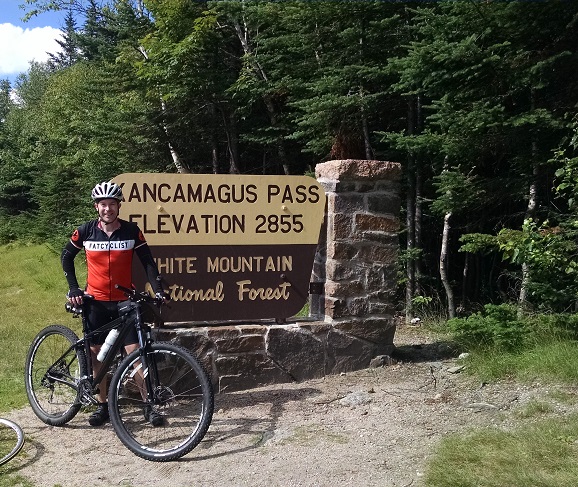 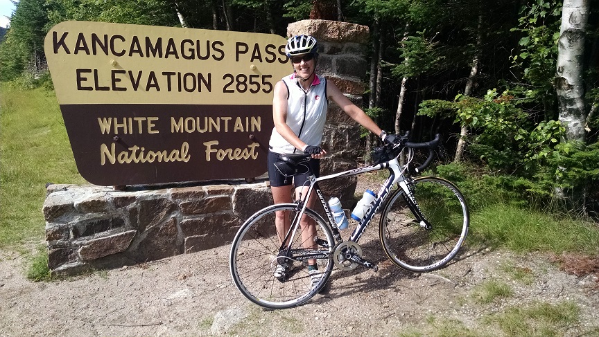 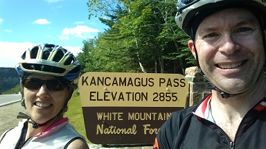 GRR: Bear Notch Ten speedy miles down, four manageable miles up, five of my favorite miles down. Betsy met us at Bart's as planned, we stocked up on 603 Brewery's finest, and headed back to the Schuss for some R&R. Leadville, I'm as ready as I'm going to be. The Numbers
|